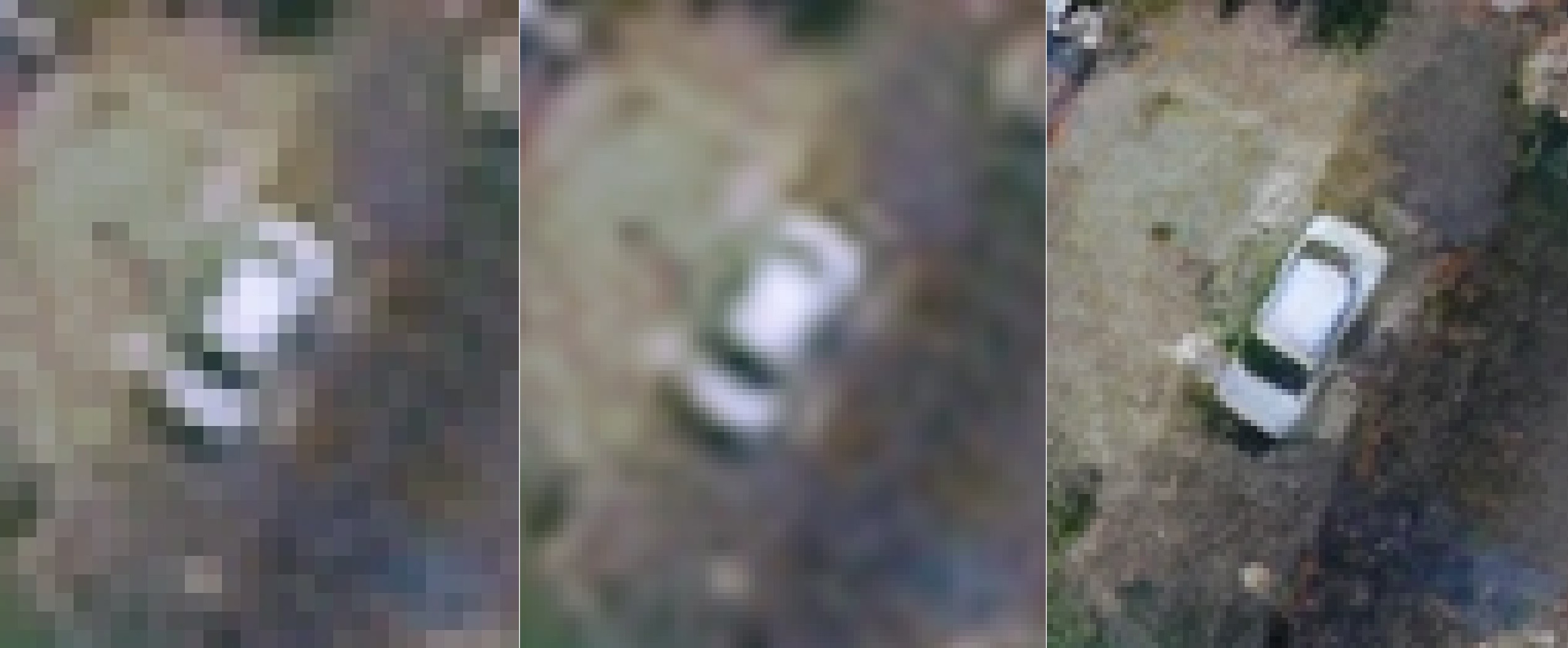
WorldView-3 · 30 cm native · Clarsat HD10 enhancement
What your sensor cannot resolve, our model reveals.
Don't take our word for it — run it on a scene you trust.
GSD is set by your sensor. What Clarsat changes is what you can see in it.
WorldView-3 · 30 cm native · Clarsat HD10 enhancement
Don't take our word for it — run it on a scene you trust.
GSD is set by your sensor. What Clarsat changes is what you can see in it.
What your analysts can interpret, your models can detect, and your customers can verify — from imagery you already collect.
Verify high-value assets, infrastructure condition, agriculture, and change over time. Reach remote or restricted regions without flying aircraft.
Light poles, signs, road markings, building edges, individual parcels. Resolve features at urban-planning fidelity from satellite imagery alone — no field teams, no drones in regulated airspace.
Higher precision for downstream object detection and classification models. Sharper boundaries and preserved radiometry — the inputs your stack already consumes, just with more signal.
Single-image enhancement. 2×, 3×, and 4× scale factors. Production-grade, not display-only.
2×, 3×, and 4× enhancement. From metre-class to sub-decimetre HD outputs. Pick the factor that fits your downstream task.
Panchromatic, RGB, and multispectral. Validated on WorldView, SPOT, KOMPSAT, and Sentinel-2 imagery.
Geometric and radiometric integrity maintained. Pixel values your downstream analytics can still trust — not just display-grade pretty.
Designed to lift downstream object detection, classification, and identification accuracy — without compromising radiometric fidelity.
Free, no credit card. Upload your own EO scene, get the enhanced output, download it.
Larger ROI, batch processing, and unbranded outputs unlock on partnership plans.
Three ways to put Clarsat into your product. Pick the one that fits your stack.
For evaluations and low-volume production
Send a tile, get a result. Hosted on our infrastructure. The fastest path to early evaluation and pilot integrations.
For sovereign data or large pipelines
Run Clarsat inside your environment. No imagery leaves your infrastructure. Licensed by inference throughput.
For vendors with their own inference stack
Model weights and integration support. Drop into your runtime, your serving. Long-term licensing, no per-call charges.
For try-on and API evaluation, scenes are processed on our infrastructure and deleted after a short retention window. For production, choose on-prem container or weights licensing — your data stays where it is.
Yes. Create a free account and try the model on your scene immediately (up to 256×256 ROI, five evaluations per day). For larger evaluation runs, request access via the partnership form.
EO imagery — panchromatic, RGB, and multispectral. Validated on WorldView, SPOT, KOMPSAT, and Sentinel-2. Support for additional sensor modalities is on our roadmap.
Yes. We provide standard partnership NDAs and can run reproducible benchmarks on your validation set. Indicate this when you contact us.
Phase-1 partnerships are negotiated case-by-case based on throughput and deployment model. We don't publish standard pricing tables until volume economics are stable.
No — ground sampling distance is set by your sensor's optics, and no algorithm changes that. What Clarsat does is recover detail buried by pixel-grid limitations and conventional resampling.
Tell us about your imagery and integration target. We'll come back with a concrete next step.
Prefer email? Write to contact@clarsat.com.